 Katy Trail Frequently Asked Questions
Here you'll find many of the common questions about the Katy Trail, but also be sure to check out the
Katy Trail Forum for lots of good questions, answers, and discussions.
How hilly is the trail?
See the
Katy Trail Elevation chart to get a good idea of where the trail is flat and where there are slopes.
The trail was built on former railroad tracks and closely follows the Missouri River (east of Boonville),
so for the most part it's exceptionally flat,
as you might expect. However, you will find some long gradual slopes between Boonville and Clinton.
There's also a steeper but very short uphill at the Boonville bridge.
Where does the Katy Trail start and end?
The trail runs between
Clinton MO in western Missouri, and
Machens MO
on the eastern end of the state (12 miles from
St. Charles). People often start or end their rides in St Charles instead of Machens,
because Machens cannot be easily reached by car, and the trail between the two locations sometimes floods or washes out.
Where is the best place to park, when driving from St Louis or Kansas City?
Click the following link for a discussion of
Katy Trail parking most convenient to St Louis and Kansas City.
From Kansas City, the
Rock Island Trail provides a closer access point.
How can I get a printed map of the trail?
The Missouri Department of Natural Resources produces a very nice trail map, which they will send you free of charge.
Just call the MO DNR at 660-882-8196 or 800-334-6946, and ask for the Katy Trail map.
The DNR tries to keep trailheads stocked with these maps.
You can also buy a sturdy
laminated Katy Trail map here on BikeKatyTrail.com. It contains not only a map but mileage
listings, town services, and other useful information.
When is the best time to use the Katy Trail? When is the trail open?
Any time is great, but my preferences are May, September, and October.
Before May, some of the businesses are closed for the season.
In late May and June, Missouri has frequent thunderstorms or just rain, so you might get drenched or have to seek cover.
July and August are hot and humid, but things cool off in September (mainly late September).
Of course, the natural beauty of the trail is enhanced by fall foliage, generally peaking in mid-October.
These are only generalizations, you could end up with a miserably hot day in early May, or a cool and refreshing day in August.
Follow this link for
Missouri average temperatures and precipitation, and current Katy Trail weather conditions.
As for the best time of day, mornings are obviously cooler, and there's a better chance of seeing wildlife.
But there is a downside to being out there early in the morning: if you're the
first person of the day
on a wooded section of trail, you might be surprised by the occasional spider web in your face!
Is the Katy Trail open at night? No, the trail is open during daylight hours only. The trail is open year-round.
What is the trail's surface like?
It is covered in crushed limestone, which packs hard and is suitable for running, hiking,
or any kind of bike (though mountain bikes and hybrids might be more comfortable than road bikes).
For runners, the surface absorbs impact well, and is much easier on runners' legs than cement or asphalt.
The crushed limestone can be dusty; you and your bike
will get dusty.
For multi-day bike rides, you may want to bring along something to clean your chain.
The trail can get a little soft during extended rainy periods.
After a rainy period, some horses may leave light hoofprints on the equestrian part of the trail.
The trail surface is not suitable for inline skating.
For perspective, here is a close-up photo of the trail surface.
See the following question & answer for an issue related to the limestone dust.
Are there any health concerns?
I had never heard of this before, but one rider mentioned that the limestone dust can be a skin irritant.
However, this problem can be avoided, as the rider explained in his note:
The first day we started out and at the first sag stop I applied sunscreen.
Later at lunch I felt some burning around my ankles. Thinking I had missed
a few spots I applied more sunscreen. That evening I had extensive
blotches on my legs. Another rider in the group observed them and
suggested that they were chemical burns from the limestone dust. I treated
the burns with cortisone and bought knee high socks for the rest of the
ride and that stopped the problem. Several other riders in the group
complained about minor burns. I think mine were the result of the
combination of sun screen to hold the dust against the skin and sweat to
activate the limestone. I've not heard or seen any advisories at any of
the sites warning riders of this problem. If that other rider hadn't been
on point with their advice I might have had more serious complications that
would have caused me to abort the ride.
Is the Katy Trail safe?
It's very safe - there is little or no crime, and many regular trail riders have never felt the need to lock
their bikes. Of course it's also much safer than cycling or running on a road with traffic.
Here's a county-by-county
list of hospitals and emergency phone numbers
for the various county sheriffs offices, just in case.
The biggest danger, in my opinion, is crossing roads and highways at intersections with traffic, such as multiple crossings
of highway 94 on the eastern end of the trail.
Cars approach at 60MPH, and drivers often are not paying attention.
Be careful!!!
Is there any dangerous wildlife?
It's always best to keep your distance from any wildlife.
But in particular, Missouri is home to some species of venomous snakes.
Brad Wilson spotted the following
two "don't mess with me" snakes,
a 9 inch baby copperhead, and a 3 foot timber rattler.
Needless to say, this type of photo is best captured with a very high-power
telephoto lens!
I have ridden the trail many times, and have never spotted either of these types of snakes.
But just be aware they are out there.
Yes, e-bikes are allowed on the Katy Trail, but motorized devices are not. According to Missouri State Parks guidelines:
All motorized equipment is prohibited except official and emergency vehicles.
Electrically assisted pedal-powered bicycles and tricycles (maximum speed of 20 mph) as well as
electrically powered-mobility devices for persons with disabilities such as motorized wheelchairs and scooters are allowed.
Yes, horseback riding is allowed between
Clinton
and the
Sedalia Fairgrounds trailhead, a total distance of
approximately 35 miles.
Trailhead parking lots along the equestrian section of the Katy Trail are designed to accommodate
horse trailer parking.
In Clinton, you'll have to park your trailer at the Henry County Fairgrounds, just across Price Lane from the trailhead.
Equestrian use is also allowed between
Tebbetts and
Portland -
use the
Mokane trailhead for horse trailer parking.
See this KT Comment discussion thread for a discussion of
concerns regarding the horses on the trail.
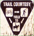
As this sign indicates, cyclists and runners/hikers should yield to horseback riders.
Be careful not to startle horses when approaching from behind.
Will my cell phone work on the trail?
Yes and no.
Most areas have coverage, although some of the more remote areas are not covered.
Naturally, areas around towns and cities are more likely to have coverage.
In my own personal experience (Verizon), I only see gaps in service around Windsor and Bluffton.
Definitely bring your cell phone along; you never know when you'll need it!
Can I cross the Missouri River Bridge to visit Jefferson City, Hermann, or Washington?
Yes, all three cities can now be reached by bridges with safe separate bike/pedestrian lanes.
To get to Washington, you'll have to ride along about four miles along highway 47 from the
Dutzow trailhead.
Hermann is about two miles from the
McKittrick trailhead.
If you are staying at a B&B in any of these cities, your host might give you a ride from the trailhead if you're not up for biking it.
We strongly encourage side trips across these bridges; you'll be rewarded with magnificent views of the Missouri River
and visits to some great Missouri towns.
See the
Hermann page,
Jefferson City page, or
Washington page
for more information on these towns and how to reach them.
Also:
Washington MO Hotels and Motels.
I don't want to go it alone - how can I get support in planning my trip, arranging lodging, etc.?
There are touring companies and various organized rides that have already worked out all the details for excellent Katy Trail trips.
Generally they will provide or arrange any needed transportation and lodging, offer maps, routes, and directions, etc.
You can leave the planning to them, so your only concern will be getting out there and enjoying the trail!
Click the following link for a Plan-a-Ride list of
companies offering tours on an ongoing basis.
Or, check the
Katy Trail events page to look for organized group rides along the trail.
Can I get my bike shipped for a one-way ride?
There are shuttle services which will carry you and your bike from one point to another - perfect for a one-way point to point ride.
Click this link for a list of all
shuttle services along the Katy Trail.
Shuttling riders across the state requires a lot of time and gasoline from the shuttle operators.
You may be able to reduce your shuttle cost by sharing a shuttle with other riders.
You can search for other riders on the
Share a Katy Trail Shuttle web page.
Another option is to ride the train in one direction, with your bike, and then pedal your bike back in the other direction.
See the next question & answer for a discussion of this option.
Some B&Bs may let you ship your bike to them.
Can I ride the train to the Katy Trail?
Many cyclists ride Amtrak (with their bikes) to some point on the trail, and then pedal back from there.
For example, St. Louis-based riders and their bikes could board Amtrak in Kirkwood, ride the train to Sedalia,
and then pedal the Katy Trail back to St. Charles / Machens.
Regarding taking the train to Washington,
see the question & answer above, discussing
crossing bridges between this city and the Katy Trail,
and the Katy Trail Amtrak guide mentioned in the following paragraph.
See the
Katy Trail Amtrak guide for a detailed discussion of riding Amtrak
along the Katy Trail.
Is camping allowed along the trail?
Impromptu "stealth" camping is
not allowed along the trail.
However, there are several private campgrounds and public parks that allow camping.
Click the following link for more details on
camping along the Katy Trail.
What's the best kind of bike tire for the Katy Trail / can I use a road bike?
In general, wider tires are better. If you're riding a mountain bike, hybrid, or comfort bike, your tires
are fine. But the Katy is definitely suitable for road bikes, and you'll see plenty of them out there.
The crushed limestone packs down hard and gives you a surface nearly as solid as asphalt, unless it's been raining a lot.
But there are a few places where it's not packed as hard, or where the trail crosses gravel roads, that could be a little rough on road bikes.
Most of what I've heard from road bikers is that any tire 25mm or wider is fine for the Katy Trail.
I've seen some riders say they did fine with 23, but most suggest 25 or wider.
For best results, go with the widest cross-tread tire your rims can handle.
You do not need knobby tires, something with light tread is ideal.
If using skinny tires, you may want to inflate to a slightly lower pressure than you use on pavement.
For a well-researched discussion of tire recommendations, read
Katy Trail Tire Selection by M L Haag MD
This topic comes up from time to time on the
Comment Forum.
Here are a few comment threads and other discussions:
Speaking of tires: always bring spare tubes and a pump or compressed air.
There are thorny plants which have given flats to many a rider.
Be prepared for possible flats!
I'd like to ride on the trail but don't have a bike. Can I rent a bike?
Yes, there are businesses at many points along the trail offering a wide variety of bikes for rent.
Follow this link for a
list of bike shops along the Katy Trail, many of which offer rentals.
Also, some of the B&B's have bikes that they make available to their guests.
What should I bring on my bike ride?
For a one-day trip, here are some suggestions:
- Plenty of water
- Helmet
- Sunscreen
- Maps, and/or screen printouts from BikeKatyTrail.com for the towns you'll be visiting
(go to the trip planner to build your customized list)
- Cell phone
- Bike repair tools
- Spare inner tubes or patch kit
- Pump or compressed air
- Insect repellant
- Tissues / toilet paper (don't count on the trailhead restrooms being stocked)
- Cash, credit cards
- Camera
- More water
For a multi-day trip, you'll need more stuff - maybe
a lot more, depending on how long you'll be riding
and how self-sufficient you plan to be
(not to mention the fact that you'll need a trailer or panniers to hold everything).
Here's a discussion on the Katy Trail Forum about
what to pack.
Here's a good packing list for serious bike touring (probably more than you'd need for the Katy Trail):
http://www.allenf.com/bikelist.htm
Is the trail handicap/wheelchair-accessible?
Yes, the trail is flat and easily reached by wheelchair from nearly all trailheads.
One exception is the
St Charles 364 parking lot
(not the main St Charles Trailhead),
which has a steep 1/4 mile long ramp that some wheelchair users might not want to tackle.
Note that
Katy Bike Rental in Defiance offers
wheelchair bikes, handcycles,
and other specialized equipment to make the trail more accessible to handicapped individuals.
Although motorized vehicles are banned from the trail, motorized wheelchairs
and scooters for the handicapped
are allowed, as well as electric bikes.
Be aware that your wheelchair or mobility device will get dusty from the
trail surface.
Has anyone ever ridden the entire trail in a single day?
How do I get my business listed on BikeKatyTrail.com?
If your business is on or near the Katy Trail, and of interest to trail users, then BikeKatyTrail wants to list you.
Please visit the
Contact Us page for a list of the info we need,
and what address to send it to.
There are no fees whatsoever to be listed here.
Want to get
your message out to thousands of Katy Trail users?
BikeKatyTrail offers reasonably priced advertising to a highly-targeted group of potential customers,
most of whom are actively planning a Katy Trail trip.
We'll even create an ad for you!
For more details, check out the
Advertising Rates page.
Why do some links within the website result in a blank page?
We hear from people having this issue from time to time. It's a browser issue, and usually it can be fixed by clearing your cache.
It's good to clear your cache anyway, from time to time, to get better results with various websites.
If you google "clear cache" along with the name of your browser (Chrome, Edge, Safari. etc), you will find easy instructions.
I spotted an error on the site. How can I report it?
I appreciate your help in keeping the site 100% accurate (so do future visitors to the site!).
Please
contact BikeKatyTrail.com with details of the error, and we'll fix it ASAP.
I love your website - what can I do to help support you?
Really, people do ask this!
If you've found BikeKatyTrail to be a useful resource, please help spread the word by telling other
Katy Trail users about the website.
Please support our advertisers - they make the website possible.
And when you patronize a trail business that you saw listed here, please tell them
that you saw them on BikeKatyTrail.com.
Finally, please consider getting
a Katy Trail t-shirt, patch, map, and/or sticker - they're really cool!
If you just want to leave a tip, you can send a donation to
Ray's Venmo account
Who built this site?
Ray Scott is an avid cyclist and a
six-time marathon finisher.
In August 2012, my son and I rode the trail from end to end (actually we crossed the state of Missouri,
from the Kansas state line to the Mississippi River, using the Katy Trail for the majority of our 310 mile ride).
In August 2013, we rode from Machens to Clinton over four days.
As a software engineer who builds commercial websites for a living,
I decided to build the ultimate Katy Trail website with all the trip-planning tools and details that
cyclists, runners, and hikers need.
I hope you'll find BikeKatyTrail to be a useful resource for all your Katy Trail information needs.